We've been enjoying the desert landscape around Los Angeles, with occasional trips through the Mojave into the southeastern Sierras, up the Owens Valley, and into the southern reaches of Death Valley. Here are some notes from a couple of those trips.
One late September, Carol had a cat show in the Mojave Desert town of Ridgecrest, California. This pleasant small town is the main community for the China Lake Naval Weapons Station, and has seen an influx of newcomers being relocated from Ventura County. The Base Relocation and Consolidation initiative moved something like 4,000 families to this sleepy little town of 24,000. We drove up very late Friday night, well after dusk, but enjoyed the quiet, traffic-free drive north of Palmdale / Lancaster on Highway 14. We stayed at an overpriced chain motel in Ridgecrest, a town filled with nice-looking $30-a-night hotels serving the military base.
 On the way to the cat show hall at the fairgrounds the next morning, we had a very pleasant breakfast at the town's Denny's. I asked our waiter whether the impact of the relocation was being felt. I was told that housing prices were increasing, that new homes were being quickly built, and that the schools would be crowded next fall. I didn't see much evidence of booming construction, especially compared to the Los Angeles area, but also didn't see a single for-sale sign on any houses.
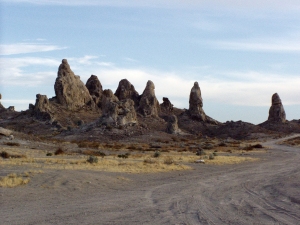 While Carol was at the cat show, I headed east and north, skirting the southern edge of China Lake, and quickly came upon the town of Trona, on the edge of Searle Lake, another huge dry lakebed. A sign pointed south across the railroad tracks and the lakebed, to the Trona Pinnacles, an otherworldly location for numerous science fiction movies.
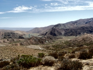
I continued north, through the partially-deserted town of Trona, and over the crest of the hills into the Panamint Valley, stretching for 70+ miles to the north. A stretch of brilliant white indicated the dry salty center of another lakebed, and the Panamint Mountains rose to the east. I drove north to the Emmigrant Valley turnoff, an entrance into the southwestern Death Valley Natio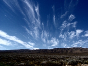 nal Park through a cut in the Panamint Mountains.
The road was navigable, but passed through a number of washouts from recent thunderstorms, very unusual for the late summer in the desert. The haze in the sky cleared, leaving only whispy horsetails rising above the hills to the west.
A line of rough mineral-capped sandstone hills arose on both sides of the road, and an immense rust-colored bluff emerged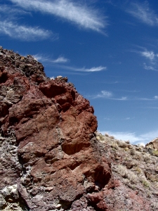 . I parked by the side of the road, and walked across a wash to the base of the bluff, and looked closer at what must have been iron-rich rocks in the bluff. Ravines on either side of the bluff led up into the hills. Huge quartz
 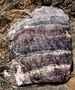 boulders were visible, washed clear of the sand in the ravine by the force of the occasional downpours.
I continued my drive northeast, rejoining the main road to Stovepipe Wells. At an altitude just above sea level, it's more than 200 feet higher than the lowest point in Death Valley.
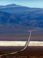
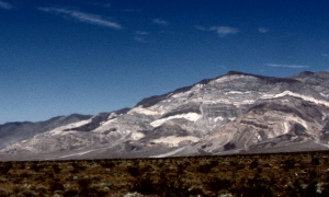 I turned around, and took the main road south and over a mile-high pass back into the Panamint Valley. Off to the right, Panamint Peak looked like a chocolate and caramel layer cake, and the road shot straight as an arrow across the lowest part of the dry lakebed. Once out of the park, I looked for other creekbeds, and found one with even more colorful boulders scattered across the sand.
Partway down the Panamint Valley, a road led across the lake bed to the Ballarat Ghost Town. A couple of geezers sat on the porch of an old shack, asking for contributions for the priviledge of talking to them, and asking even more for warm sodas at their feet. Other than these characters, the remains of Ballarat consisted of a few rusty mining implements and a slumping stone wall.
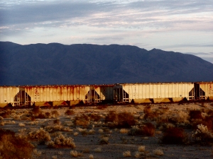 After picking Carol up at the fairgrounds after the cat show, we drove back to the Trona Pinnacles. As the sun set, it brilliantly illuminated the clouds and the train cars waiting for loads of minerals to be processed in Trona.
We got up early the next morning, ate another pleasant meal at the Ridgecrest Denny's, and left town by driving southeast across the western edge of Searle Lake towards Red Mountain and the town of Rand. We encountered a huge off-road motorcycle race taking place half-way there, with the bikes shooting plumes of dust into the sky. A flagman waved us through a road crossing for the race, and on we went.
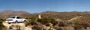
 From Rand, we drove on seldom-travelled roads across the Mojave, with another huge dry lake to our south. Roads led out onto the lake, and we stopped at one that also crossed a huge dry wash, where we saw dozens of lizards basking in the sun and showing their defiance to us by doing push-ups. We wandered around a while, in amazement at the richness of the desert landscape, before heading back towards Highway 14, near Red Rock Canyon State Park, and the BLM off-road vehicular area just south of it at Jawbone Canyon.
Two miles up the canyon the blacktop ended and the true off-road experience began. We encountered spectacular geology in the form of a huge pale green mountain ridge to the south and a pale green rounded mount to the north. We later learned that this mount is called "Blue Point," though the BLM staffer we asked had always wondered why, since it was so obviously green. We stopped and picked up chunks of the green rock, which was considerably lighter than copper ore from Michigan's upper penninsula. Copper oxide? I'm not sure. In any case, the broad swipe of green was a mile wide, thousands of feet high, and many miles long.
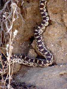
 We drove further up into the hills up Jawbone Canyon Road, eventually turning around after reaching a local maximum at an altitude of just under 4000', more than a half-mile above the plain below. We could see a line of power-generating windmills lining the ridge of the southern Sierra on the horizon to the northwest of us. Carol had her eyes peeled for birds and any other wildlife she could find, and spotted this 8-foot gopher snake lazing on the embankment at the side of the road, at about 3200' altitude.
We made a brief stop at the BLM office on the way out, saw a friendly desert tortoise, and then made our way back home to the Conejo Valley.
Every few years, after winter's rains have tapered off, Carol and I drive to the Antelope Valley California Poppy Preserve, west of Palmdale. Our early habits generally hold us in good stead, allowing us to get into the preserve and find a parking spot before the throngs arrive behind us. We meander through the preserve, 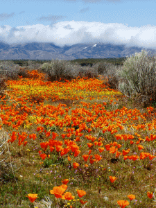 and then drive in a more-or-less northwesterly direction back to Interstate 5. We continue westward through the town of Frazier Peak and into the National Forest. The frequent road washout warnings are somewhat of a deterrent - for the winters of 2021 and 2022, each have caused roughly year-long road closures.
One year we managed to get to Highway 33, north of Ojai, but found it blocked by barricades and national forest rangers to keep us loonie drivers out. We took a slight detour - 200 miles - to Santa Maria along the northern side of the mountains that have Santa Barbara and the coast on their southern edge. The first time we thought that we had good maps, but couldn't find paths through the mountains to short-cut our ride. Not a problem, though - the wildflowers in that valley were, again, spectacular, coloring entire mountainsides bright yellow and pink. Next time, we were better prepared, and took National Forest roads from Highway 166 to the Zaca Mesa Winery, the back way.
Each year yields more surprises in the area of Carrizo Plains National Monument.
Last Updated February 02, 2024