We have travelled to Arizona occasionally for family vacations combined with professional activities. Our first was a visit to Scottsdale for the Cat Fancier's Association annual meeting and awards ceremony. Subsequent trips for Ventana Conferences (near Tucson), the Winn Feline Foundation grant review meeting (in Chandler), a family trip with Carol's brother and sister-in-law, where we bypassed cities entirely, and a trip to Tucson for a recent CFA Annual. We had a great time on each of these outings; here are some of the things we did.
Our first day took us from Phoenix to Sedona. We had intended to take Schnebly Hill Road from Interstate 17 into town, but found it closed due to the fire danger from the extremely dry conditions. Instead, we drove back south from Flagstaff down 89A through a glorious canyon that opened up around us as we descended towards Sedona. The red rock formations emerged from the canyon walls as we crossed back and forth over the creek. There were very few cars on the normally-crowded road (we were permitted through a checkpoint in Flagstaff only because we had reservations that evening in Sedona), and the merchants and innkeepers in this resort area were conspicuously hurting.
We settled into our hotel, enjoyed the pool, and struck out for dinner. We found a "unique" Thai place, entered well before the evening rush, and enjoyed vegan Thai cuisine. As we ate, the place filled up with all sorts of characters from the area - all evidently well in tune with the psychomagnetic vortices (or whatever!) that surround Sedona. Regardless of the validity of the New Age claims, Sedona is a wonderful locale.
![[Image]](../Files_and_images/wupatki_n_m_3.gif) When we left Sedona, we were unable to drive back north through the canyon, but had to take the southern route back to I-17. Retracing our steps around to the east of Sedona, we travelled back north to Flagstaff, and then took 89 northeast through town toward the eastern entrance to Grand Canyon National Park. About 10 miles north of Flagstaff, we left 89 and drove through Sunset Crater and Wupatki National Monuments. This area, containing very young (~900 year old) volcanic calderas, is also scattered with ruins of settlements dating to just before and just after the emergence of the Sunset and other craters. As we drove north from the Sunset Crater area towards Wupatki, we stopped every few miles to gape at the house-sized lava bombs that had been ejected from the volcano and were slumped by the side of the road. Amidst the lava, desert plants and insects had taken hold, occupying a very fragile ecological niche.
When we left Sedona, we were unable to drive back north through the canyon, but had to take the southern route back to I-17. Retracing our steps around to the east of Sedona, we travelled back north to Flagstaff, and then took 89 northeast through town toward the eastern entrance to Grand Canyon National Park. About 10 miles north of Flagstaff, we left 89 and drove through Sunset Crater and Wupatki National Monuments. This area, containing very young (~900 year old) volcanic calderas, is also scattered with ruins of settlements dating to just before and just after the emergence of the Sunset and other craters. As we drove north from the Sunset Crater area towards Wupatki, we stopped every few miles to gape at the house-sized lava bombs that had been ejected from the volcano and were slumped by the side of the road. Amidst the lava, desert plants and insects had taken hold, occupying a very fragile ecological niche.
We stopped again at the Wukoki Pueblo site, where we talked with some archeological researchers who were taking detailed GPS readings of the ruins. They described how the settlement seemed to occur coincident with the climate changes induced by the volcano, and how the settlements had failed once the climate had settled back into its pre-volcano drought conditions. We also talked about the relationship between Wupatki and Chaco Canyon (with their very similar stacked dry rock construction techniques), and the cultures that preceeded the pueblo-builders that had established trade routes with the Hopewell Indian cultures of the Midwest. I gawked a bit at their equipment (they had a telemetry base station on a nearby hilltop and were carrying wireless LAN-based GPS and laptops), and generally enjoyed our conversation. In the mid-afternoon sun (probably 100+ degrees), we didn't stay out long once we finished talking.
Our first glimpse of the periphery of the Grand Canyon was on the east entrance road, as the canyons of the Little Colorado River deepened and widened to our right. By the time we saw the Harvey Company's Indian Watchtower at Desert View, the Little Colorado River had joined the main Colorado River, and the Grand Canyon lay out before us in all its splendor. The tower itself, designed in the 1920's by Mary Colter and completed in 1932, exemplifies a sensibility that is somewhat lost on me - synthetic tourist kitsch (with the involvement of a Hopi artist, Fred Kabotie, to lend an air of authenticity) that has itself passed into the lore of the national park. Don't get me wrong - the tower is fun to explore, and offers great views of the Grand Canyon and the river below - but it really doesn't fee right to me.
After finding our hotel south of the main park entrance, settling in, and getting a good night's sleep, we returned to the park early the next morning to reconnoiter the South Rim. I had anticipated horrendous crowds, but really didn't feel like there was an oppressive presence of people. We walked along the rim from Hopi House (another Mary Colter artifact) to the top of the Bright Angel Trail, taking in the sights and talking to the rangers and naturalists about what we were seeing. An amateur astronomer had a chair-based telescope focused on Venus, visible in the day in the clear Arizona air. Carol, of course, bird-watched the entire time. We quickly found the California Condors, and also found the naturalist that was monitoring them using a radio receiver and directional antenna, picking up the transmissions from the wing-tags they wore. Carol helped a number of people spot the birds, particularly on their cliff-side roosts below.
We returned to our hotel to spend the heat of the afternoon in the swimming pool, then went back into the park during the late afternoon and early evening. We scouted out the parking spots near the West Rim entrance, and ate dinner at the El Tovar hotel. I got just what I asked for, a window-side table, and sat in the glare of the setting sun for a half-hour or so, but then enjoyed watching the dusk settle over the Canyon after sunset. After dinner, we drove over to Yavapai Point, where the Tuscon Astronomy Club had set up numerous telescopes. The kids and I had a chance to see M-31, the Ring Nebula, some brilliant views of the Moon - great fun! It was too dark to bird-watch, so Carol spent that time in the car.
![[Image]](../Files_and_images/South_Rim_2.gif)
Carol and I returned to the park that evening to do some bird watching, watching the condors once again, and also got up early the next morning. We ate breakfast at Bright Angel lodge, did some souvenir-shopping for friends, and made it back to our hotel in time to grab the kids and head over to the horseback-riding concessionaire in the National Forest.
After leaving the Grand Canyon, we headed back south to Flagstaff via Williams, and then east to Meteor Crater, which is definitely worth seeing once. The story of the deciphering of the puzzle of the crater is fascinating.
We then found ourselves in Hollbrook, where we stayed overnight, and got up very early the next morning to drive through the Petrified Forest National Park. This park was formed to preserve the remnants of an extensive deposit of petrified trees that had been picked through for decades by settlers. If these are the remnants, the original must have been incredible! We talked to the rangers, and to nearby residents, who said that much more petrified forest in the vicinity is yet to be uncovered by erosion or excavation. Once through the park, we returned to the mineral shops
After leaving Hollbrook, we drove south through Snowflake / Taylor, an affluent couple of towns that seem to cater to the retirement set. These were very green after the sere high plains around Winslow and Hollbrook, but still extremely dry.
We avoided Show Low by driving through a nearby state park area, and then headed south to try to get on the Mogollon Rim drive south and west. This road was also closed due to the extemely dry conditions, so we continued down to Carizo and Ft. Apache, where we diverted briefly to see the Kinishba ruins, which show signs of recent habitation (tarpaper and concrete in the front part of the ruin) as well as a long history. The White River provides welcome moisture to the valley, providing for the prosperous community farms. The walls of the valley have strange blocky building-like protruberances, and north of Fort Apache and Whiteriver, evidence of the fires from the 1990's were quite apparent.
As we travelled north back toward Pinetop / Lakeside, a resort community east of Show Low, we began to see what looked like a cloud on the western horizon. We stopped for a break in Pinetop, and could now see the base of the billow, down in the forest we had just left. People were talking about the start of a forest fire, and as we drove towards Show Low, announcers on the radio described efforts to bring firefighters onto the scene, and that no extensive call-up was needed.
Boy, were they wrong! Over the next week, this fire grew to be one of the largest in Arizona history.
Rather than stay in the Pinetop / Show Low area, we opted to drive west to Payson, about 90 miles from the fire. We found Payson to be a delightful little town, with a climate that permitted forest growth. Near Payson is the Tonto Natural Bridge State Park. The natural bridge was formed when water eroded away the limestone that comprises the structure in that area. The erosion formed a bridge rather than a gully, and travertine ribbons and sheets are populated with cliff swallows. The creek is accessible only through a strenuous (for Carol, at least) climb down a steep trail on one end, and down a broad but long set of steps at the other end. We managed to step from boulder to boulder in the creek, and really enjoyed the cool, clean air. We climbed back out to the blacktopped parking lot on top of the bridge, and immediately felt the sweltering heat of the summer sun.
Unfortunately, Arizona's budgetary woes have caused the temporary closure of this wonderful state park - please check before you go.
Our next stop was the Scottsdale Princess Resort, for Carol's participation in the annual International Cat Fancier's Association meeting. Carol spent her time there giving presentations on the American Shorthair breed, and accepting awards. The kids and I spent our time at the pool! The resort has a miniature water park, and movies are shown nightly while the audience lounges in the water or poolside.
It's hard to not eat Mexican food while in Arizona. Somehow, we managed :-( We did find Sushi on Shea, a really nice Japanese restaurant (which seems to be closed now), and ate there two or three times.
One very very hot afternoon, the kids and I visited Frank Lloyd Wright's Taliesin West. Greg was inspired by the architecture, enjoying it far more than I expected. My impressions about Frank Lloyd Wright's self-perceived infallability, cultivated by visits to the Robie House and other Wright structures in the Midwest, were confirmed. It wasn't that I feel he was wrong, necessarily, but just not terribly considerate of the people for whom he was doing arcitectural design.
We connected up with my cousin, Nancy Blumenstein, who moved from Chicago to Fountain Hills a few years ago. We'd been corresponding for 25 years, but hadn't met for 35 or more. Nancy is even more cheerful in person than in her writing.
Carol and I visited the Desert Botanical Gardens one morning. I really enjoyed the architecture and xeriscaping ideas, and Carol really enjoyed the birdwatching and planting ideas. We had a very pleasant discussion with a retiree who was doing volunteer work at the Botanical Gardens, and a very pleasant walk through the grounds.
In the late 2000's and into the 2010's Carol travelled almost annually to Tucson for the Ventana Conference. We'd plan her trips in such a way that we could spend a few days at the conference backup hotel, Westward Look Resort. We found the accomodations to be delightful, as well as the in-house restaurant, where we'd meet our friends Dawn and Gerry, for drinks and dinner.
Each time we visit Tucson, we visit the Arizona-Sonora Desert Museum, just south of the western unit of Saguaro National Park, through which we drive on our return. Always spectacular!
While Carol was occupied with her conference, I'd poke around Tucson, where I hiked on Mount Lemon, Bear Canyon, found a great shoe store, and explored the Saguaro National Park.
Whenever we're in the area, we stop at Green Valley and Madera Canyon, on the side of Mt. Wrightson, about 40 miles south of Tucson. This canyon, below the summit at 5,000' elevation, sees lots and lots of migratory birds as they fly from peak to peak along the "Sky Islands" of Arizona and New Mexico. In addition to the migratory birds, there are flocks of wild turkeys, dozens of Coatis, and in the plains below, Javalinas. In the spring, this is an absolutely delightful area, and this year was no exception.
We generally stay at Madera Kubo B&B, a collection of rustic and ideosyncratic cabins high up in the canyon. Much of the furniture is hand-made, as are many of the window frames, etc. This place has probably seen its best days some decades in the past, but it's still charming. It's also located about a mile south of the Mt. Wrightson trailhead. A creek runs through the B&B, hung with hummingbird feeders, seed feeders, orange halves, and other delicious treats for birds. Many birds gather at the feeders, providing a great opportunity for the avid birdwatcher. At night, turkeys perch in the trees, and we've seen javalinas and ringtails hanging about.
I'm not one of those avid birdwatchers, so while Carol (and occasionally her brother and his wife) find birds, the trails on Mt. Wrightson call to me. I hike to "Sprung Spring / Josephine Saddle" each time we go there, and I've managed to climb to the peak once, zig-zagging up the switchbacks on the north side of the mountain. On our most recent trip, temperatures at Madera Canyon were in the 60's, with no wind, while at Baldy Saddle just below the peak, the temps were below freezing and the winds were above 30 mph. Personal safety (my own) persuaded me to skip the peak & go back down. That was a 3800' climb & descent in about 11 miles (I took the "Super Trail" up and the "Old Baldy" trail down).
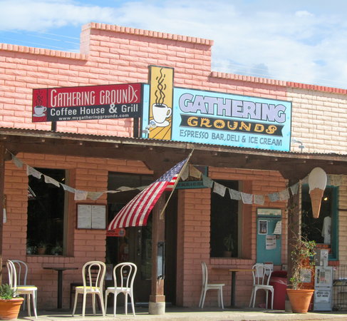 Green Valley is a cute little town, but doesn't really have much in the way of restaurants (we did try, and were generally happy with, Arizona Family Restaurant). We often go to Tubac or Patagonia for dinners. Tubac is an artsy little town with lots of restaurants. We've tried Tubac Jack's and less recently, another restaurant that we enjoyed, but is now out of business. In Patagonia, we generally stop at Gathering Grounds, where we get great deli sandwiches, a cup of soup, and a nice drink, for not very much money. Obviously a neighborhood favorite; lots of people there, and all quite happy. We've tried to get into the Wagon Wheel, where we were told that lunch wouldn't begin until 1:30 pm or later (!).
While in the Madera Canyon area, we occasionally get to Kitt Peak Observatory, where a friend had done some work while doing his PhD in Astrophysics. It's got a great visitor's center, and some really nice picnic grounds in addition to the spectacular telescopes. This year, the wildflowers were particularly nice on the road to / from, and the spur up the mountain to the observatory itself.
We often visit friends in Sierra Vista, and the Ramsey Canyon Preserve, a world heritage site. Our friends have a good handle on the local restaurants; they took us to Pizzeria Mimosa in Hereford. We had absolutely spectacular service there from Angie, and great food. Highly recommended!
After leaving Sierra Vista, we made our way through Bisbee and Douglas to Portal, on the southeast edge of the Chiracahua National Monument, a small mountain range near the New Mexico / Arizona / Mexico border. Just below the mountains, we stopped for a brief visit at the Chiricahua Desert Museum & Geronimo Event Center, well worth the visit. It has plenty of artifacts and history, and there is a very nice collection of desert plants, lizards, turtles, and snakes, not to mention beautiful sculpture, in enclosed gardens outside.
Carol's brother and sister-in-law had already arrived, and made reservations for us at the Portal Peak Lodge, a "pop-up" motel and ancient main building in the small town of Portal, at the mouth of the canyon. It's an interesting place, made (I think) from somewhat up-cycled FEMA emergency lodgings carted into place, wired up, and voila! Instant motel! Portal Peak Lodge has the only restaurant for miles (decent food, and live entertainment on warmer summer evenings). Cave Creek emerges from the Chiracahua Mountains to the east, presenting steep walls of rock formations, pocked with caves well above the canyon floor. A small settlement lies scattered around the Lodge, including a fire station, a library, and a handful of older houses.
We ate dinner at Portal Peak Lodge, then did a quick tour around the area. A neighborhood, Arizona Sky Village, has a number of widely-spread homes with their own observatory domes, as this is a part of North America with very little light pollution. Many of the homes offer birdwatchers access to their properties (with a free-will offering) as well - very nice!
We arrived in Portal without having filled up in Sierra Vista - a mistake, as our next day was to be a day of driving around birdwatching. The nearest gas? In Animas, a tiny hamlet 25 miles east in New Mexico. And, the Valley Mercantile closes at 8 pm, though the pumps are automated and continue working through the night, using credit cards. We set out just after dark, found our way there by braille, and returned to collapse into bed. 50 mile round-trip for gas!
 The next morning, we drove over to the campsite at Sunny Flats, where I set off on a hike along Cave Creek and then up the Silver Peak trail while the rest of the party went birdwatching. Fortified with a hot cross bun and some snacks for my hike, off I went. Almost immediately, I discovered an old blockhouse, a remnant of the area's mining past. Then, to the ranger station, the Silver Peak trailhead, and my course upwards through the scree and shingle of the mountainside. The view up, and then back down, was really spectacular. After a nice three hour climb, with plenty of switchbacks and blowdowns, I attained the summit, where I found another old shack, an outhouse, a helipad, and the concrete platform on which a fire tower had once existed. There, an ammo box contained a log book; the summit's most recent visitor had arrived two days before. I left a note, and a granola bar, and headed back down. Two and a half hours later, I wandered back to the campsite, where I collapsed into the camp chairs and awaited the family's return.
After recovering from my hike, we drove over to Cave Creek Ranch, where birdwatching is offered to the public on the main building's front porch (a somewhat less than free-will offering of $5 per person is requested). Very nice place; that's probably where we'll stay the next time we go. More javalinas, more deer, more hummingbirds, more crazily colored local and migratory birds, and very peaceful environment.
The next day was completely taken up by a 720 mile drive home, through Tucson, Phoenix, Quartzite (where we stopped to look at gems & minterals at a roadside stand), Palm Springs (stopped in nearby Yucaipa for dinner), San Bernardino, Pasadena, Los Angeles, and finally to Thousand Oaks.
Last Updated February 02, 2024